
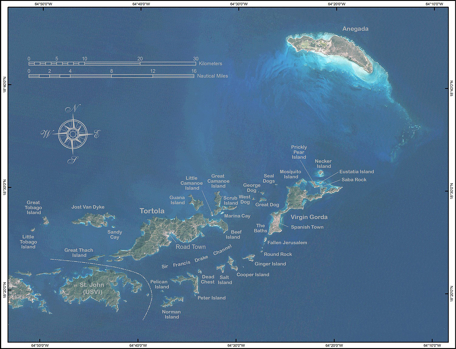
Click on one of the main islands to find out more information.
 $(document).ready(function(e) { $('img[usemap]').rwdImageMaps(); });
Four Main Islands
Tortola
Tortola (Spanish for Turtle Dove), largest and most populated of the four main Islands, is a lush mountainous Island which was formed by volcanic activity. Crowning Tortola is the tallest peak, Sage Mountain National Park, at 1716 feet, which exhibits the characteristics of a tropical rain forest. The Island has a population of 24,045 and 55.7 sq. km (21.5 sq. mi) in size. Tortola is also the vibrant hub of the financial and government sectors with Road Town "The Small Town with a Big Heart" as its capital. Road Town is home to the beautiful J.R. O'Neal Botanic Gardens which features close to three acres of indigenous and exotic plants, trees and herbs. The capital is also filled with restaurants, shops, and is the site for the hospital, government administration offices and official Governor's House with its historical museum. Just behind Waterfront Drive is Main Street, a peep into the BVI's architectural past, which still has many historic buildings and churches, charming cafes, and curio shops as well as the Virgin Islands Folk Museum.
Tortola also provides the main port of entry for a growing mega yacht and cruise tourism industry. Beef Island, an island in the British Virgin Island, is located to the east of Tortola, and the two islands are connected by the Queen Elizabeth Bridge. Beef Island is the site of the Terrance B. Lettsome International Airport (IATA code EIS), the main commercial airport that serves Tortola and the rest of the British Virgin Islands. Adjacent to it is sailboat-filled Trellis Bay, a unique cultural village with craft shops and restaurants.
The first inhabitants of Tortola, around 300 B.C., were Amerindians from the Ciboney tribe of Venezuela. Around 200 A.D., they were overthrown by the Taino Arawak. In the 1300s, the fierce Carib invaded the British Virgins and enslaved the Arawaks.
 Columbus was the first European visitor to the islands, in 1493. Impressed by the number of islands and by their plentiful cays, he named them after Ursula and her 11,000 virgins. In the 16th century, the English, who had successfully taken control of the area from the Dutch, established a permanent plantation colony on Tortola and the surrounding islands. The sugar cane industry, dependent on the slave labour of Africans transported from the continent, dominated Tortola history over the next 180 years. It diminished in the mid-19th century after the abolition of slavery. A large proportion of the white landowning population left the British Virgin Islands during the economic downturn, but the political relationship between the island and the British continued and has been maintained.
In the late 1970s, the British businessman Ken Bates attempted to lease a large part of the island on a 199-year lease, but this was blocked after a protest movement led by islander Noel Lloyd. Inspired by Martin Luther King, Noel Lloyd, started the Positive Action Movement in 1968 to protest the Batehill company’s development of land in the territory. The Batehill leases “were to run for 199 years…leaving less than 10% of Anegada to its own people, and creating a barrier that would separate the affluent Road Town harbour from the rest of the island.” Today, a life size statute of Noel Lloyd and face plates of other members of PAM stands in memory of their efforts at the Noel Lloyd Positive Action Movement Park in Road Town, Tortola.
 Virgin Gorda
Virgin Gorda is the third largest island of the four main islands. It is located approximately 18 degrees north and 64 degrees west. It has an area of 8 square miles and it was nicknamed the Fat Virgin by Christopher Columbus because the islands profile on the horizon looks like a fat woman lying on her side. The capital of Virgin Gorda is Spanish Town.
The first residents in Virgin Gorda history to populate the area were the Ciboney, Arawak, and Carib Indians, who made a life throughout the first millennium AD by farming and fishing its abundant natural resources. Christopher Columbus was the first European visitor in Virgin Gorda history, spying what was to become the British Virgin Islands and touching down there on his maiden voyage in 1493, though no European nation chose to settle the unusual scattering of land masses until much later. A smorgasbord of notorious inhabitants, rather, called the area's coves home during this period in Virgin Gorda history - pirates, like Bluebeard and Captain Kidd used Virgin Gorda as a base from which to hound Spanish galleons that passed through the reef-laced waters on a regular basis.
Virgin Gorda’s history took a step into modernity when it was finally taken over by the British in the late 17th century, when a booming plantation sugar industry was established and the population of Virgin Gorda increased dramatically. Slavery was abolished by Britain in 1838, a momentous occasion in Virgin Gorda history but one which left a fractured economy floundering for decades. This was finally rectified when the development of modern travel and communications allowed offshore banking and tourism to take over the British Virgin Islands' economy, which led to some of the most amazing growth in Virgin Gorda history. Residents of Virgin Gorda now enjoy a high standard of living and value the benefits that a booming, though controlled, tourism industry has offered.
The island contains many tourist attractions such as the Baths. The Baths is located on the southern end of Virgin Gorda. This tourist attraction shows evidence of the island’s volcanic origins as huge granite boulders lie in piles on the beach, forming scenic grottoes that are open to the sea.
The centrepiece of this dramatic area on Virgin Gorda's north shore is The Baths, a geological wonder comprised of awe-inspiring granite boulders, which form sheltered sea pools on the beach's edge. The protected area also includes Devil's Bay, which can be reached from The Baths by a series of ladders scaling the boulders. Just north of The Baths, Spring Bay is reached by a separate road and includes a lovely white sand beach
The most notable ruin on Virgin Gorda is the Old Copper Mine. It was recently designated as a national park. It was mined in the 1860's by Cornish miners. This abandoned copper mine played an important role in the history of Virgin Gorda. Spaniards passing through the BVI were the first Europeans to mine coppers here in the early 18th century. However, Cornish miners built the ruins that remain today in the 1800s, following a decline in mineral deposits in Cornwall, England. The mine closed in 1862 due to escalating expenses and low market prices. As many as 130 Cornish labourers and their families lived on Virgin Gorda during this time. The ruins of their housing area and the operations centre, containing the powerhouse, mine shafts, cisterns, engine house and chimney are still visible scattered across the slopes.

Anegada
Named Anegada or the “Drowned Land” by the Spanish, Anegada is the only coral island in the Virgin Islands’ volcanic chain. This Island is 10 miles long by 2 1/2 miles wide with extensive salt ponds. It also reaches its highest point at 28 feet, hence its name which means the "drowned land." Of coral reef origins, Anegada has "extruded" sixteen miles of sandy beaches with a primeval quality.
Anegada is known for miles of white sand beaches and the 29 km (18 miles) long Horseshoe Reef, the largest barrier coral reef in the Caribbean, and the fourth largest on earth. The reef makes navigation to Anegada difficult. While charter boats freely sail among most of the other Virgin Islands, charter companies often forbid clients to sail to Anegada to avoid running aground on the reef.
The reef has claimed hundreds of shipwrecks, including HMS Astraea in 1808, the Donna Paula in 1819 and the MS Rocus in 1929. As such, it was once an important scuba diving destination. In an effort to protect the reef, the BVI government has made anchoring on Horseshoe Reef illegal.
Apart from the miles of white sand beaches, Anegada is also known for the large salt ponds which cover much of the western end of the island, and unique fauna. In the 1830s, thousands of Caribbean Flamingos lived in these ponds, but they were hunted for food and feathers throughout the 19th and early 20th centuries and disappeared by 1950. They are now being re-established into the ponds. The birds are another tourist draw, but officials are trying to keep the number of visitors to the flamingo areas at a level that allows the birds to flourish.

Jost Van Dyke
Jost Van Dyke is the smallest of the four main islands of the British Virgin Islands. Jost Van Dyke, named after a famous Dutch pirate, has been a sailor's mecca for years. Like many of the neighbouring islands, it is volcanic in origin and mountainous. The highest point on the island is Majohnny Hill at 321 meters (1,054 ft).
Although the English captured the BVI in 1672, it seems that Jost Van Dyke was mostly ignored until the mid-18th century. A map drawn of the BVI in 1717 by Captain John Walton does not depict either Jost Van Dyke or Little Jost Van Dyke.
The island of Jost Van Dyke is rich in history as well. Captain ‘Joost van Dyk’ was a 17th Century Dutch pirate who used its harbours as a safe hideout and to attack ships passing North of the island on way to Puerto Rico, Santo Domingo, and Cuba. Jost has been home to Arawak Indians, Carib Indians, Africans, Dutch and English planters. In the 1700s, a Quaker colony settled here to develop sugar-cane plantations. There are overgrown ruins of Quaker buildings and burial sites in different parts of the islands. Historically in the Caribbean, with the exception of the Amerindians, most people just started living near the water in the last 50-75 years. Before that, settlers, planters, and freed slaves made their homes in the safe, harder to reach highlands and valleys. This gave them a certain degree of added safety being able to spot thieves, pirates, or foreign Navy ships approaching.
Great Harbour, the main port of entry, is always bobbing with sailboats and sailors coming ashore to the charming West Indian village that lines the beach with gift shops and restaurants. Since the late 1960s, Foxy's Bar in Great Harbor has been a popular stop for Caribbean boaters. Foxy's and the other bars in Great Harbor now host a modest crowd year-round and are filled with thousands of partiers on New Year's Eve (locally known as “Old Year’s Night”).